
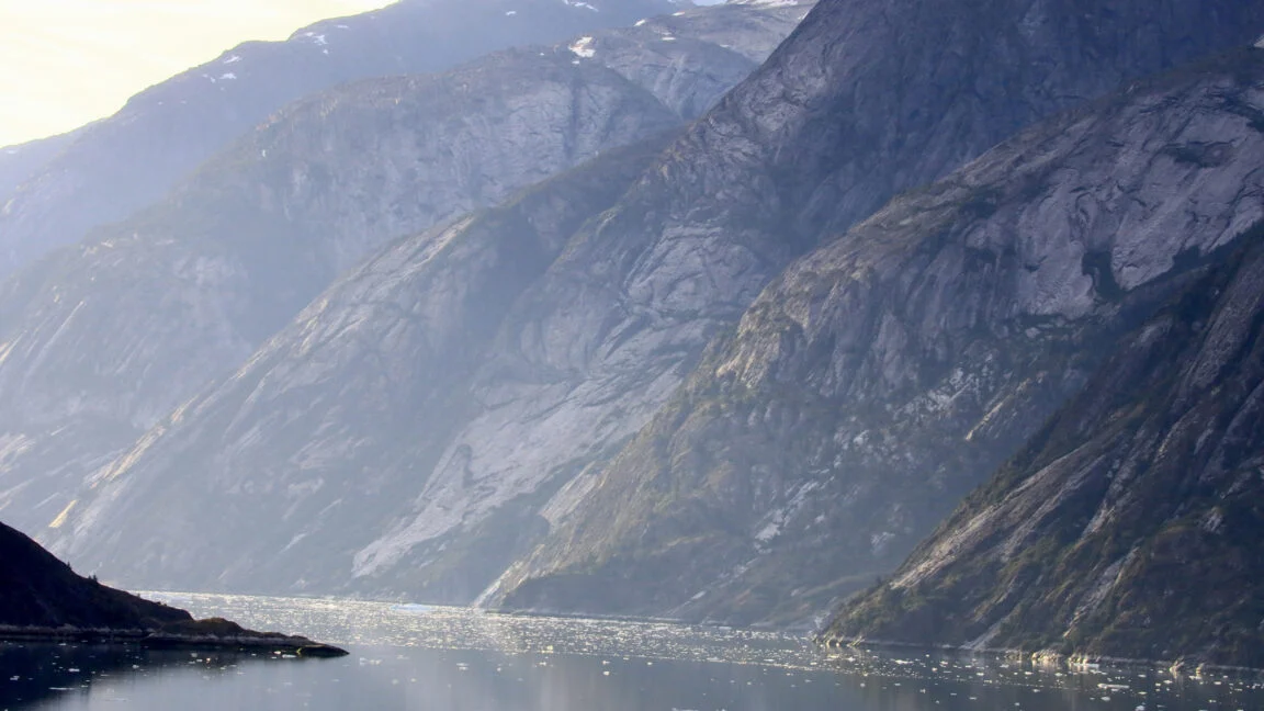
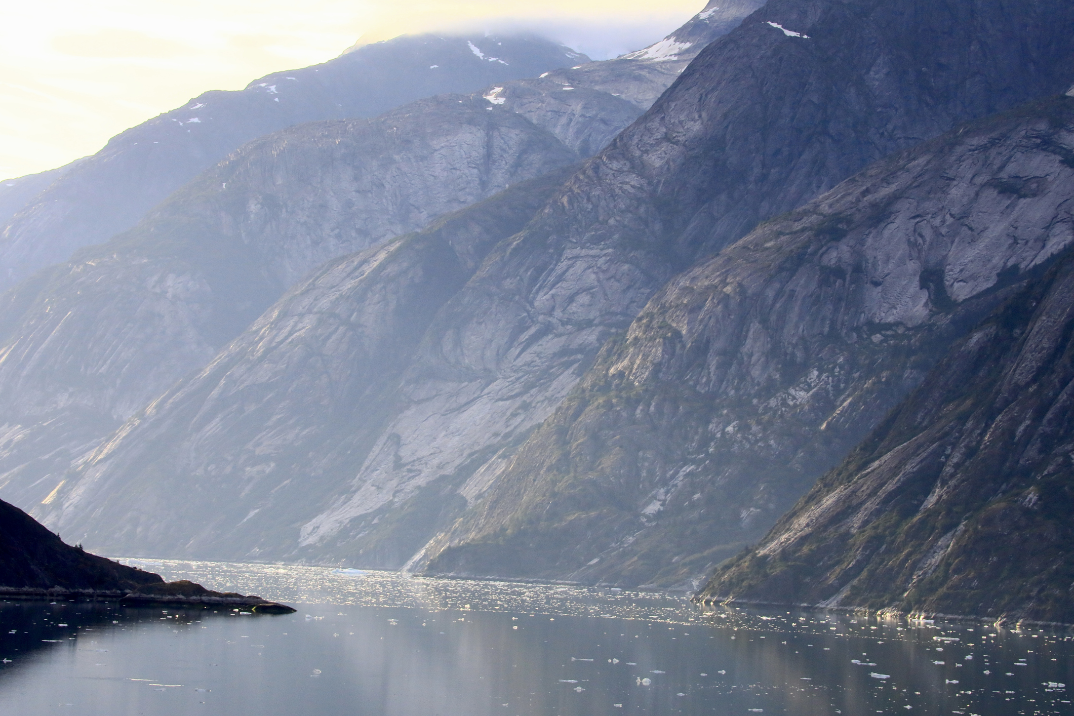
In the early morning hours of August 10, 2025, a cataclysmic geological event unfolded in the remote wilderness of Alaska’s Tracy Arm fjord. At 5:26 a.m. local time, a massive section of a mountain face—comprising at least 63.5 million cubic meters of rock—detached and plummeted into the deep, frigid waters near the terminus of the South Sawyer Glacier.
The impact generated an initial wave reaching 100 meters in height, which tore through the narrow confines of the fjord at speeds exceeding 70 meters per second. Upon striking the opposing shoreline, the water surged upward, reaching a staggering 481 meters above sea level. This event, now recognized as the second-highest tsunami ever recorded in human history, serves as a chilling testament to the escalating risks posed by climate-driven landscape instability.
"It was the second-highest tsunami ever recorded on Earth," says Aram Fathian, a researcher at the University of Calgary and co-author of a recent study published in Science. "But until now, almost nobody heard about it because it was a near-miss event."
A Chronology of Collapse: The Final Hours
While the event itself lasted only moments, the stage for this disaster had been set over decades. The stability of the mountain slope was historically maintained by the South Sawyer Glacier, which acted as a structural "ice straitjacket." As global temperatures have climbed, the glacier retreated, leaving the rock face unsupported and increasingly fragile.
Retrospective analysis of satellite imagery indicates that there were no obvious warning signs—such as large tension cracks—visible in the weeks leading up to the collapse. However, beneath the surface, the mountain was failing.
Seismometers in the region began detecting microseismic activity as early as August 5. Initially, these tremors were sporadic. By August 9, the frequency of these "mini-earthquakes" had accelerated to one per hour. In the final six hours leading up to the main event, the intervals between seismic signals shrank to between 30 and 60 seconds. Roughly one hour before the final collapse, these discrete signals merged into a continuous, grinding slip, indicating the final failure of the rock mass.
When the rock finally succumbed to gravity, the resulting energy release was global. The impact was registered by sensor stations worldwide as equivalent to a magnitude 5.4 earthquake. The violent displacement of water created a standing wave, or seiche, that reverberated through the fjord for 36 hours.
Supporting Data: The Climate Connection
The research team, led by Fathian, utilized high-resolution satellite imagery to reconstruct the slide’s geometry and evaluate the rate of glacial thinning in the Stikine Icefield. Their findings suggest that the collapse was a direct consequence of industrial-era warming.
Summertime temperatures in the region have risen by approximately 1.1°C since 1875, driving the regional snowline upward by roughly 169 meters. This warming has led to rapid glacial retreat. Between 2013 and 2022, the ice bracing the specific failure site thinned by 100 to 130 meters. By July 2025, the very base of the slope—previously shielded by glacial ice—was fully exposed.
Without the immense pressure of the glacier to hold the rock in place, the slope could no longer support its own weight. The loss of this icy support meant that the mountain was essentially waiting for a trigger to fail, a process now recognized by geologists as "paraglacial adjustment."
The "Miraculous" Close Call
The Tracy Arm fjord is a popular destination for tourism, with over 20 boats navigating its waters daily during the summer months, including large cruise ships carrying thousands of passengers. The fact that the tsunami occurred at 5:26 a.m. is widely considered a stroke of extraordinary luck.
Despite the early hour, the force of the tsunami was felt far beyond the immediate impact site.
- Harbor Island: Located 55 kilometers from the source, a group of kayakers reported water rushing past their campsites 20 minutes after the slide. Their gear was swept away, and one of their kayaks was lost to the current.
- No Name Bay: Observers on a motor vessel documented a 2–2.5 meter wave cresting along the beach, followed by a secondary 1-meter wave.
- Fords Terror: 85 kilometers from the epicenter, the crew of a small cruise boat watched as a surge of water poured over a sandbar and lifted their vessel three meters, despite the tide being in a natural state of retreat.
Perhaps most significantly, the National Geographic Venture, a cruise ship carrying approximately 150 people, was anchored near the mouth of the fjord during the event. The captain reported significant currents, white water, and a deluge of ice and debris. The ship was saved not by proximity, but by the jagged, shallow seabed at the fjord’s entrance, which acted as a "speed bump," dissipating the wave’s energy before it could strike the vessel.
Implications for Global Safety and Policy
The Tracy Arm event is a warning for other regions where glaciers are retreating. Similar geological conditions exist in Greenland, Norway, New Zealand, Canada, and various parts of Alaska. As these regions continue to warm, the structural integrity of their mountains will continue to degrade, increasing the probability of similar landslides.
"Some of these cruise ships carry up to 6,000 passengers," Fathian warns. "This is literally a floating city. Imagine one of these ships getting hit by a megatsunami wave."

The rise in cruise ship traffic in Alaska—growing from roughly 1 million passengers in 2016 to 1.6 million by 2025—has significantly increased the human risk profile. Despite this, many high-risk areas remain unmapped in terms of landslide or tsunami hazards.
The researchers advocate for a new approach to hazard mitigation, specifically calling for:
- Integration of Seismic Monitoring: Utilizing the "precursory warning signals" observed in Tracy Arm—specifically the accelerating microseismicity—to create real-time early warning systems.
- Geological Risk Mapping: Policymakers must prioritize the identification of slopes that have lost their glacial "straitjackets" and are therefore at high risk of failure.
- Regulatory Oversight: Establishing "no-go" zones or real-time monitoring requirements for cruise operators in areas identified as high-risk.
Conclusion: The New Normal
The 2025 Tracy Arm tsunami was not an anomaly; it was a symptom of a rapidly changing planet. As permafrost thaws and glaciers retreat, the mountains of the world are becoming more dynamic and dangerous.
The scientific community is now calling for this data to reach the desks of regulators and policymakers immediately. The "miraculous luck" that prevented a tragedy in 2025 cannot be relied upon as a strategy for the future. By combining advanced satellite imaging, global seismic monitoring, and a proactive approach to climate risk, researchers hope to turn the lessons of Tracy Arm into a shield for the thousands of people who explore these fragile, beautiful, and increasingly volatile landscapes.
The event serves as a sobering reminder that while the natural world may appear static on a human timescale, the ongoing climate crisis is accelerating geological processes at a rate that our current safety protocols are not yet prepared to handle. The "silent giant" of the Tracy Arm may have been the second-highest tsunami in history, but without significant intervention, it is unlikely to be the last.